Author: Nur Fasihah Ngah Seron | 29 May, 2022
The need to control development intensity is essential in achieving a sustainable built environment of an area. A city with high intensity may result in urban sprawl because of the rapid growth [1]. Hence, the government has implemented several initiatives to counter this issue. The development intensity of an area can be controlled based on two factors:
- Plot Ratio control for commercial and industrial area.
- Density control for residential developments.
Plot Ratio
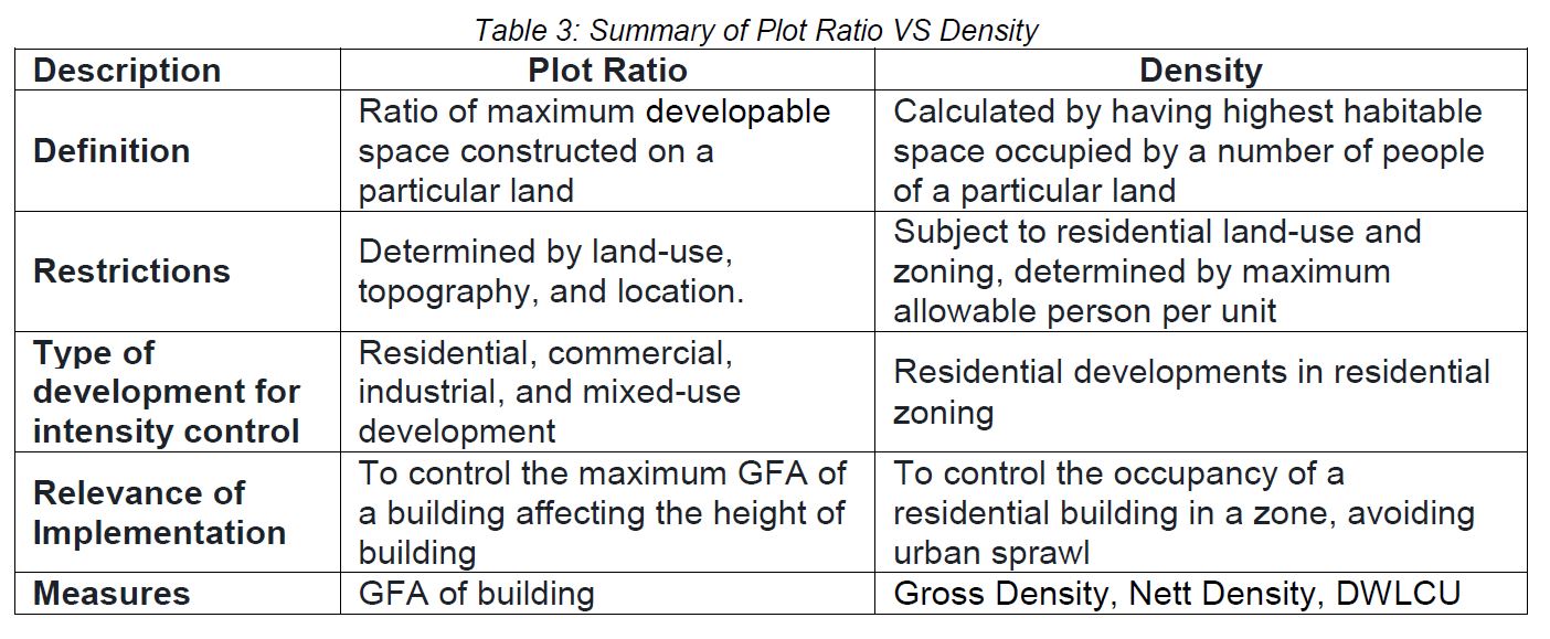
According to Town & Country Planning Act 1976, plot ratio is the ratio of the total floor area of a building plot as measured between the survey boundary lines or, if there are no survey boundary lines, between the provisional boundary lines [2]. It defines the maximum area and intensity of developable space which can be constructed on a specific plot of land. Plot ratio does not determine the building height limitation, but there are some restrictions imposed under particular local planning zoning development. This restriction will limit the overall Gross Floor Area (GFA) of a building depending on the maximum plot ratio. Hence, a minimal plinth area size will result in a higher building height/storey [3]. This does not include the above-ground car park.

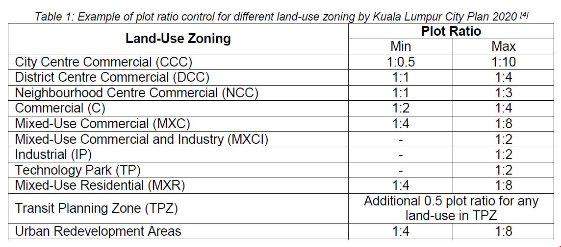
Plot ratio in Malaysia is set by different local authorities in accordance with the respective state guidelines. The gap of maximum limit differences for a plot ratio could be greater in different states. For instance, some areas in Kuala Lumpur, the plot ratio is set to a maximum of 1:10 for both commercial and residential, as stated in Kuala Lumpur City Plan 2020 (KLCP2020), whereas the local authority in Kedah set its plot ratio to 1:3.
Plot ratio is controlled by the implementation of Floor Area Requirement (FAR)FAR limitations imposed for commercial development, industrial and mixed-use development are based on the designated zones, whereas FAR for residential is controlled by the dynamic rate of development and living trend within a city centre.
Plot ratio is determined by several factors, including land-use, land topography, location, etc. [3]. For example, land located in a risky area such as on a hilltop or hillside will generally resort to a lower plot ratio. Comparing a site with the same land-use, a site located within a central business district may have a higher plot ratio of 1:8, whereas a suburban residential area may have a lower plot ratio of 1:3.
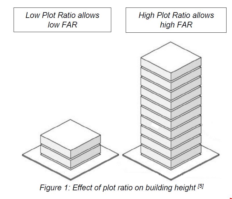
The higher the plot ratio is, the higher the allowable allocation of GFA is within the site. It is important to define the maximum allocation of the development. A higher plot ratio would also offset the site value to higher land cost. For instance, under DBKL Infrastructure and Planning Department, any residential, commercial, industrial, and mixed development buildings which exceed the allowable plot ratio, will be charged prior to the development, as referred in Pelan Pembangunan Lengkap PPL 1039. Hence, any excess should be approved by the Comprehensive Development Plan (CDP) and Centre Planning Area (CPA) prior to the development [6]. A high plot ratio leads to a high population density of the area. For example, in KLCP 2020, the government had set a plot ratio capped to 1:10, which was applied to both commercial and residential development. Hence, projects approved with a higher plot ratio than the permissive plot ratio under KLCP 2020 would have to resubmit their proposals to obtain new approvals. With these regulations, the saturation of vacant properties in the city could be reduced and the land price could be controlled.
Density
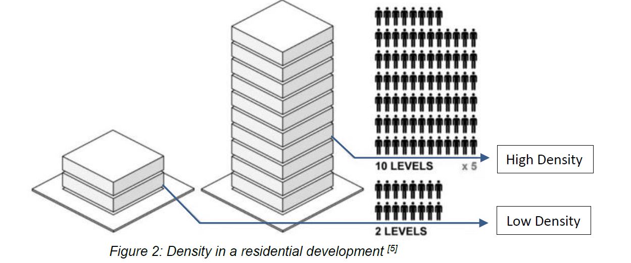
According to Town and Country Planning Act 1976, Part I Section 2, “Density” is the intensity of land-use reckoned in terms of the number of persons, dwelling units, or habitable rooms, or any combination of those factors, per unit area of land. “Habitable room” in the statement does not include a kitchen, storeroom, utility room, lavatory, bathroom, or garage [2]. According to Federal Territory (Planning) Act 1982, density is the intensity of use of land reckoned or expressed in terms of the number of persons, dwelling units, or habitable rooms, or any combination of those factors, per unit area of land [7].
Density control serves to determine the amount of newly proposed housing schemes within site. Its purpose is to avoid urban sprawling outside designated zones and to encourage concentrated development within areas covered by public transportation and infrastructure [4].
The need of density control is based on the need to maintain and regulate of [4]:
- Site character.
- The character of the surrounding area.
- Preservation of amenities for existing and future residents, including the provision of public open space, landscaping, and car parking.
- The necessity to establish a critical mass of people to back urban amenities such as public transportation, local stores, and schools.
- Provisions for different housing types (apartment, bungalow, terrace, etc.) in Kuala Lumpur to meet the needs of different communities.
Density calculation is required by the local authority (Jabatan Perancangan Bandar) to be included in a development proposal as an instrument to grant development permission on a land before any commencement of construction on that particular land. Any excess in density as approved by the Comprehensive Development Plan (CDP) and Centre Planning Area (CPA) plan would be charged under the development fee [6].
In order to determine the population density for the purpose of application of Planning Permission, it can be achieved by three different methods, Gross Density Calculation, Net Density Calculation, and Density Without Low-Cost Unit (DWLCU) calculation [8].
 *For Gross Density Calculation, the Total Proposed Land Area for Residential includes any public amenities components, infra and, any material related to public facilities.


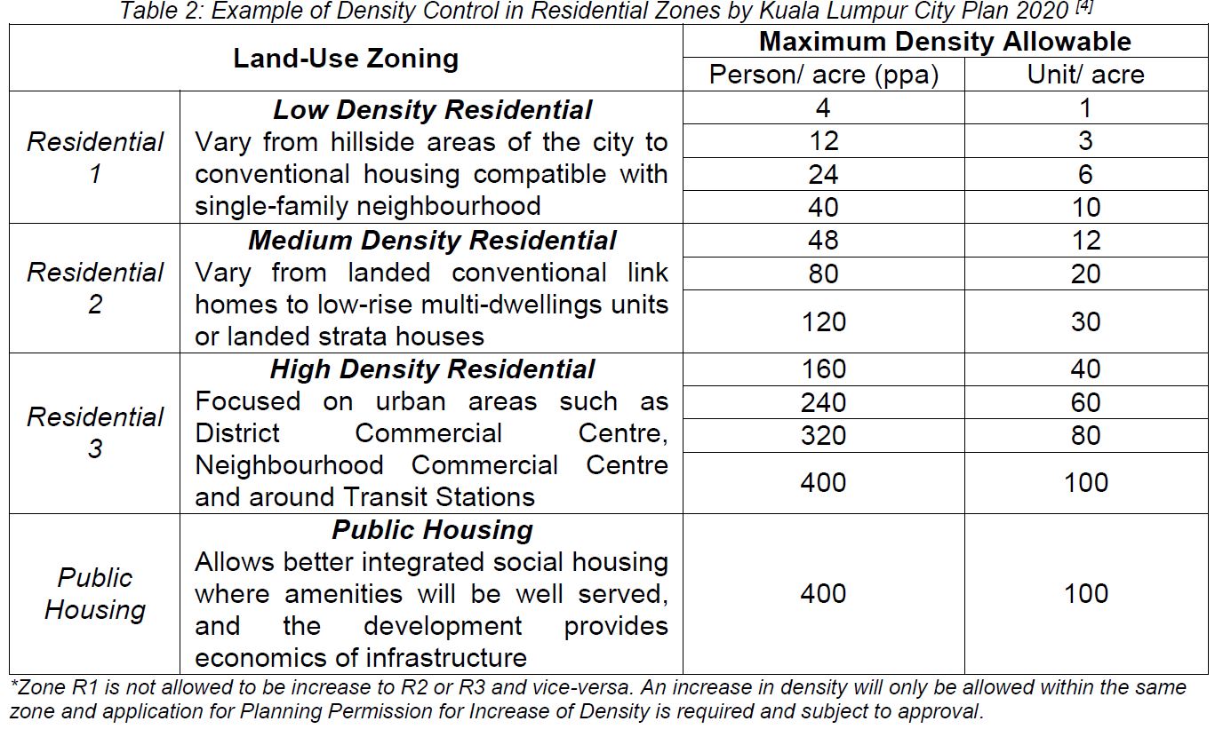
Table 2 shows the guidelines for Density Control set by KLCP 2020, where there are four main categories of residential density that shall be a control measure for residential development intensity. The maximum number of people per acre for residential density indicates the allowable density for residential development in Kuala Lumpur [4].
Conclusion
The purpose of designated plot ratios and density control is to achieve a sustainable development intensity, to avoid over-development, as well as a critical mass to support urban services. Sustainable growth from different perspectives, such as in social and economic could be foreseen in the future [4]. The draft of Kuala Lumpur Structure Plan 2040 (KLSP2040) has been planned by the local authority to guide the city’s development towards a sustainable city with long-term viability [9]. Cooperation and effort by local authorities are needed to develop Kuala Lumpur into a world-class city for the future generation through these interesting strategies.
Nur Fasihah Ngah Seron
Assistant Technical Manager
IPM Professional Services Sdn Bhd
References:
[1] I. Yin, and J. Abdullah. The Development Control of Urban Centre in Kuala Lumpur, Planning Malaysia: Journal of the Malaysian Institute of Planners, 2020
[2] Laws of Malaysia – Act 172 Town And Country Planning Act 1976, Incorporating all amendments up to 1 January 2006
[3] iProperty. “What Do Property Buyers Need To Know About Plot Ratio In Malaysia”. Retrieved on 29th May 2022 from https://www.iproperty.com.my/guides/plot-ratio-malaysia-property-buyers/
[4] Kuala Lumpur City Plan 2020, Volume 1 – Towards a World Class City
[5] density architecture, a study on high density residential architecture. Retrieved on 29th May 2022 from https://densityarchitecture.wordpress.com/
[6] Garis Panduan Pengiraan Caj Pembangunan, Isf Dan Cagaran/ Deposit Runtuhan. Jabatan Perancang, DBKL, 2006, Unit Penyelidikan Dan Pembangunan,
[7] Laws of Malaysia – Act 267 Federal Territory (Planning) Act 1982, Incorporating all amendments up to 1 January 2006
[8] Saiful Nizam Hj Ali. Guidelines on Property Development in Malaysia. Retrieved on 29th May 2022 from https://www.academia.edu/5173271/GUIDELINES_ON_PROPERTY_DEVELOPMENT_IN_MALAYSIA
[9] Pelan Pembangunan Kuala Lumpur 2040. Retrieved on 29th May 2022 from https://klmycity2040.dbkl.gov.my/pppkl/